Posts

Showing posts from July, 2017

Day 38, Denali Part 1

Image
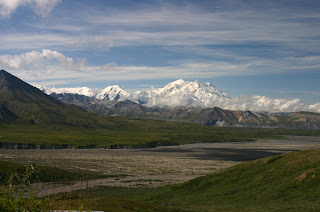
We arrived in Denali Friday, July 28.  It was only about 160 miles from where we were in Fairbanks so we had plenty of time and a mostly sunny day.  By the time we arrived, it was nearly clear so we set up quickly and headed into the park to an area that was relatively higher than the surrounding area to see if there was any chance to see "the high one," Denali.  By relatively higher, I mean we were about 3200 feet above sea level while our campground is about 1700.  As we were still about 75 miles from the mountain, it took a little bit to get a fix on it and to set up the cameras to get a decent shot. Perspective shot from Eielson Visitors Center Shot of Denali Friday Afternoon.  75 miles away. Shot from Eielson Visitors Center Tuesday.  30 miles away  There were clouds around the lower areas and a persistent cloud at the very top but we began shooting pictures on the hopes that we might get a good one to use in this blog.  Our plan is to take a bus Tuesda

Day 42 Fairbanks, Alaska

Image
This has been a different kind of week for us camping only in Fairbanks. There have been plenty of things to see and do here so we have been enjoying the time, especially since we have not had to move the camper.  Last Saturday, we started at the farmer’s market.  We were surprised at some of the vegetables and didn’t expect any fruit but there were some fresh wild blueberries.  I think they must have been grown in the gold field as they were priced at $10 for 18 oz.  We spent the rest of the day getting the laundry done- two weeks since the last time- followed by a quiet evening catching up on some reading and correspondence. Sunday, we visited the First United Methodist Church here.  As it was downtown, we spent the better part of two hours at the visitors’ center/museum.  One of the things that particularly impressed me about most of the towns and villages we have been in, is their pride in their history.  Not just the modern era history, but also the First Nation history and h

Companion's Comments

Image
Dick has encouraged me to add my comments about our travels, so here we go! While Dick was raft packing and hiking in the Montana wilderness with Matt, Hunter and Boy Scouts, I had the incomparable and never before pleasure of nine days on my own at Two Medicine Campground on the east side of  Glacier N.P. I had no schedule, no appointments, no phone service and no one to be responsible for except our Sparky! I slept in, took naps if I wanted (even once in the morning!), read books, learned about Queen Esther from Bible study material, took long walks and even hiked 5 miles round trip to lovely Running Eagle Falls. I had purchased a Rocky Mountains Wildflowers identification book and set out to see how many I could find. In just that hike and small area were 36-40 colorful varieties. After all, my mother was a biology teacher, so the love of beauty such as that comes naturally. I also boarded a 1938 small cruise boat with the goal to join a few others on a guided hike to Twin Falls.

Day 35, Fairbanks, AK

Image
We have covered a lot of miles since Watson Lake, Yukon.  We made good time leaving Watson Lake so decided to head on to Whitehorse, Yukon.  It was rainy most of the drive but quit by the time we arrived in Whitehorse.  We crossed the Continental Divide just before passing through Teslin, Yukon at 1031 meters elevation.  We have been having fun doing the conversions on speed, distance and elevations along the way.  1031 meters is about 3,300 feet.  I know through this section of road, the gas mileage on the truck was lower with all the ups and downs. We stopped in Teslin to see a couple of museums dedicated to the First Nation people indigenous to that area.  The first was by a man, George Johnston, that began photographing his people beginning in the early 1900's until his death in 1974.  He also had the first car in that area, a 1928 Chevy that he used as a taxi for the three miles of cleared roadway he cut.  Once the Alaska Highway was built in 1942, he was able to travel much

Day 29 Watson Lake Yukon Territory

Image
After two nights at Muncho Lake Provincial Park, we traveled to Watson Lake in the Yukon Territory.  The campsite at Muncho Lake was right on the water and we had a wonderful restful time. Muncho Lake    No Viagra needed 😉 The rest day was spent at Liard Hotsprings.  The temperatures ranged from about 134 degrees at the inlet to about 95 at the lower end.  Very soothing and refreshing after several days on the road and hiking. We met a couple from Fort Nelson so learned a lot about the area, economy, and politics.  They come often to the lake for fishing and relaxation. Our drive today covered about 170 miles intentionally, seven black bears, three groups and some single bison, so we could stop as desired and we would have time here in Watson Lake to see some of the sights including the Sign Post Forest which was started in 1942 by one of the soldiers that was missing home so he erected a sign with the mileage home to Danville, IL.  It has been maintained and is now part o

Day 26 Leaving Dawson Creek on the Alaska Highway

Image
We have been in Dawson Creek now for two days and have had time to clean and wash the truck, sweep out the camper really good, bathe Sparky, get the propane tanks filled and take a road break.  We visited the Alaska Highway Museum and found it quite informative with lots of good photo exhibits and a documentary of the building process and problems.  Considering the challenges and unknowns, it is pretty amazing that they were able to build 1533 miles of road through terrain that, in itself was challenging, but also under conditions that none of the engineers had ever seen before. So, tomorrow morning, we start at milepost 0, to cover in 12 days of fairly easy driving, what it took them only 8 months to build.  The road is totally different and improved over what they ended up with in Nov.. 1942, but is essentially the same route. 0 down, 1533 to go With the prediction of rain today, which was minor, we took a side trip yesterday to Tumbler Ridge and on to Kinuseo Falls in the Monk

Day 24

Image
Arrived in Grand Prairie, AB this afternoon at Tamarack RV Park.  We have a good wifi connection. We have spent the last five days driving north through the Canadian Rockies.  Awesome view after awesome view.  Our first stop after Waterton was at Castle Mountain CG in the Banff National Park. We were late getting there to secure a site but managed to park at the picnic pavillion. The next morning we headed north to Lake Louise and the Icefield Parkway. We spent time hiking some of the trails.  We took the shoreline trail at Lake Louise to get away from the constant crowds.  The lake is a beautiful sight but I was disappointed in the commercialization.  We did go into the lobby of the Fairmont Hotel there to see the grandeur of that building.  It certainly has spectacular views from the lake side rooms. After leaving the Lake Louise area, we continued north toward the Icefield Parkway.  On arriving at the Wilcox CG, we found the road impossible to get into because of hikers parking

Day 19

Image
Chief Mountain We left Glacier NP yesterday about 8:45am and headed north.  Once north of Many Glacier access road, it was all new territory for us.  We turned on to Chief Mountain Highway for scenery and to cross the US-Canada border.  We had seen Chief Mountain more than 120 miles from the east as we approached Glacier NP on June 22 and the boys had seen it from the deck on the back of the MOHAB headquarters, more than 120 miles south.  It is a spectacular sight.   We crossed into Canada just north of there and had no issues at all.  Spent about 15 minutes answering a few questions and they did a quick search of the truck for any contraband.  They forgot to hand us our passports but we caught that before leaving the parking area.  They were a little embarrassed.   We had a long descent into the Waterton Park area and again were greeted with some spectacular scenery.  We are camped at the Waterton Townsite CG with a site in partial shade and next to the lake.  Pure chance se

Northbound Tomorrow

Image
We are now at the end of two weeks since we left home and will be heading north across the border tomorrow. The past week has been a different and great week for both Jeannette and I.  Jeannette spent the week in Two Medicine CG, campground, in Glacier NP for the week while I was packrafting with Matt and Hunter and the Boy Scout troop at MOHAB, near Dupuyer, MT.  I will let Jeannette add her week experiences at the end of this entry. Jeannette dropped me off at the base camp last Sunday.  At MOHAB, the staff began training and instructing that evening.  The boys picked out the trip they wanted and on Monday, additional training, packing for the trail, putting together food supplies, and receiving the pack raft and related gear consumed most of the day.  The final event was to take a full pack shakedown hike of about 2 miles. Tuesday, the final instruction occurred and the drive to the trailhead was made, nearly 2 hours into the Bob Marshall Wilderness.  We got just a little over a